
Having Geospatial Intelligence (GEOINT) at your disposal is a valuable asset to any military, but existential threats in Asia-Pacific bring a new dimension to the need for timely availability of this information, with a number of options now available to this end.
Regional threats, such as the People’s Republic of China’s maritime and territorial claims in the East and South China Seas, and the monitoring of a nation’s borders, are key drivers behind the need for up-to-date GEOINT, as is the often prominent threat from nature, such as extreme weather that can debilitate whole cities, regions and even countries through the region. Having persistent surveillance of a specific location allows nations in the Asia-Pacific to identify changes in certain areas, and map, analyse and locate what is happening in their own countries, and at increasing stand-off ranges, the goings-on of their neighbours: “Geospatial intelligence has always been, and still is, evolving in the Asia-Pacific region, but GEOINT has become significantly more important, not only in defence but the broader aspect of national security,” Chris Fowler, national security lead for the Asia-Pacific at Esri, told AMR: “Nations are faced with, and must be prepared for natural disasters, technological disasters, criminal activity, public health emergencies, social unrest and intentional attacks; both foreign and domestic.” GEOINT requires persistence, so satellites and high-altitude Unmanned Aerial Vehicles (UAVs) are often used to provide this level of data. In order to carry out this persistent GEOINT surveillance within the earth’s atmosphere, UAVs offer the most promising option for the tedious data collection task. Meanwhile, satellites can provide imagery from a stationary position, and are therefore the ultimate persistent capability. However they cannot be easily manoeuvred whereas UAVs, on the other hand, can be deployed where needed, and fly continually for long durations while constantly collecting data.
Illegal activities can be timed around the blind spots produced by orbiting satellites, and UAVs can help overcome this. These aircraft can be deployed at a far quicker rate with less planning, when compared to satellites, so predicting their planned operations and flight paths is more difficult for adversaries. Nevertheless, in the Asia-Pacific there is little investment being made in indigenously-developed high-end, GEOINT-capable UAVs, so nations that can afford it are turning to American technology to bolster their intelligence-gathering capabilities. Collection of GEOINT data using UAVs such as the Northrop Grumman RQ-4B Global Hawk aircraft and General Atomics’ MQ-1/9 Predator/Reaper UAVs was made starkly apparent during recent US-led operations in Iraq and Afghanistan, where they were used to bolster satellite data monitoring activities and changes in patterns-of-life near troops and known insurgent hotspots. Since the end of these operations, the benefits that a persistent, yet manoeuvrable, capability as offered by UAVs has spread internationally, not least of all to the Asia-Pacific where these systems are being acquired and are highly sought after. However, UAVs are a sophisticated and costly acquisition, so nations with the larger defence budgets are the only ones opting for this capability at present, and even then, are yet to receive delivery of such systems.
The Republic of Korea (RoK) and Japan have both selected the RQ-4B, with deliveries of four to the RoK to be completed by 2019, and an authorisation for the sale of three to Tokyo made by the US government in 2015. The RoK is acquiring a multi-intelligence sensor suite for its RQ-4B Block-30 UAVs comprising a synthetic aperture radar and ground moving target indicator, plus a signals intelligence payload. Flying at 60000 feet (18288 metres) and operating at a range of 12300 nautical miles (6641.5 kilometres) the RQ-4B can carry a large payload for over 30 hours, which brings advantages to operators seeking information on changes to patterns of life. It is also an all-weather system, so high levels of humidity and extreme weather that is commonplace in the Asia-Pacific does not affect the operation of the aircraft, enabling these UAVs to effectively be operated non-, akin to satellites. Additionally, the US Air Force stations its RQ-4Bs at Anderson airbase in Guam, in the Pacific, and Misawa airbase in the southern part of Japan’s Honshu island, with the latter providing an ideal location to monitor activities in the Democratic People’s Republic of Korea (DPRK).

While the acquisition of such a high-end surveillance aircraft is arguably antagonising to neighbouring countries with which there are tensions such as the PRC and DPRK, the stand-off capability that the RQ-4B offers could mean that Japan and the ROK, with the help of the US, could monitor the whole region without being detected by these potentially hostile actors. The Royal Australian Air Force, furthermore, is set to acquire the RQ-4B-derived MQ-4C Triton maritime UAV, which could further extend the high-altitude surveillance reach of militaries in the region. The USAF is also in the process of assessing the plausibility of transferring the Lockheed Martin U-2S reconnaissance aircraft’s sensor suite on board the RQ-4B, which could increase its GEOINT capability. To this end, the UTC Aerospace Systems Senior Year Electro-Optical Reconnaissance System-2 (SYERS-2) has been tested on the RQ-4B and testing of the UTC Aerospace Systems’ MS-177 that will replace this sensor in the future is also planned. The SYERS-2 can sense through the atmosphere and into closed airspace, which lends itself to the persistent surveillance that nations in this region such as Australia, Japan and the ROK are looking for. The developmental MS-177, which offers longer range target identification and increased coverage per hour compared to the SYSERS-2, has also been tested on General Atomics’ Avenger UAV, and is expected to move to RQ-4B testing in 2017.
While the export of high-end sensor technology such as the MS-177 is likely to be limited, the future deployment of this level of sensing to the region, in line with the US military’s focus on the Asia-Pacific, will inevitably lend itself to allied nations that share what are considered to be similar threats to Washington-DC. India is another regional nation that also has both its eye on unmanned technology, plus border tensions with Pakistan, that it is keen to monitor. New Delhi has reportedly expressed interest in both the MQ-9 and RQ-4B, and its recent initiation into the Missile Technology Control Regime, a multilateral agreement which covers the exports of missiles and missile technology, could move it closer to acquiring such capabilities either domestically or internationally.
Regionally, the PRC has a strong satellite network, and it pays for other nations in the Asia-Pacific to keep atop of the capabilities owned by their ubiquitous neighbour, but very few are rushing to launch their own GEOINT satellites when other equipment is higher on the military shopping list. However, the benefits of using GEOINT are apparent, and while it can be a costly capability to own if a sovereign system is sought, nations have instead selected to utilise commercial constellations that are offering GEOINT on a services basis.
Private Sector
Leonardo and Thales’ joint venture Telespazio uses its satellite constellation to provide GEOINT services to nations in the Asia-Pacific, from operating bases located in Europe but which serve the international market: “Satellites provide the ability to monitor wide and/or inaccessible areas frequently and on-demand,” Massimo Claudio Comparini, head of geo-information at Telespazio, told AMR. Mr. Comparini continued that geospatial information is often integrated with “traditional information” produced from outlets such as aircraft and vessels, which together will produce: “the best situational awareness possible in the shortest time with the minimum risk for people and assets.” Rome-based e-GEOS is a Telespazio/Italian Space Agency joint venture, which operates earth observation centres in Matera, southern Italy and Neustrelitz, northeast Germany, through which access can be gained to a number of satellites, including the Italian Space Agency’s COSMO-SkyMed satellite, by countries in the Asia-Pacific: “The Asia Pacific area is relevant from a geopolitical point of view,” Mr. Comparini, who is also the chief executive of e-GEOS, notes: “Immigration issues, deforestation and illegal fisheries require continuous monitoring using geo-information, in particular from satellites due to the inaccessibility of the region.”

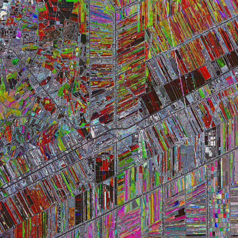
Medium-sized satellites are used to provide synthetic aperture radar-based imagery, and can repeat the same observation of an area several times to build up a location-based picture. SAR benefits from gathering imagery in all weathers, which is useful in the Asia-Pacific given high levels of humidity in certain parts of the region: “Taking into account the weather conditions (mostly clouded), radar satellite images are particularly useful,” Mr. Comparini adds: “In the last ten years, this area has been devastated by the biggest tsunamis, earthquakes and typhoons ever registered in the world … Telespazio, through e-GEOS is mapping and monitoring the impacts (of such phenomena) on the land and at sea, using our own emergency rapid mapping service and also through the Copernicus Emergency Management Service project.” The latter is an initiative by the European Union to provide information regarding natural and man-made disasters to assist responders.
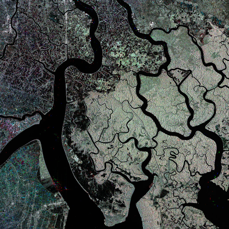
In terms of regional military applications, the SAR technology provided by the COSMO-SkyMed satellite includes maritime monitoring. The retrieval of this information, which includes ship positioning, is carried out within 30 minutes of a satellite passing, the company says. A high resolution ‘spotlight’ mode, meanwhile, coupled with the frequent revisit of the satellite, allows for detection and monitoring of changes at sensitive military targets. Mr. Comparini says that commercial services lend themselves to military operations largely because of cost and efficiency:
Away from the e-GEOS initiative, in order to support demand, a new GEOINT satellite in the form of the WorldView-4 developed by DigitalGlobal will join previous legacy members of the WorldView satellite family (WorldView-1, -2, -3 and -4) that are already providing services to military customers. Scheduled to be launched from Vandenberg airbase, California on 6 November the satellite will provide a panchromatic resolution of 300mm (11.8 inches) and multi-spectral resolution of 1.2 metres (four feet): “With the additional (300mm) capacity that we’re bringing online with WorldView-4, and the investments we’ve made in our constellation Direct Access facility programme (see below), we are meeting the growing demand from new and existing customers alike,” Jeffrey Tarr, DigitalGlobe’s chief executive, told AMR. Making 15 orbits per day at an altitude of 367.7 nautical miles (681 kilometres) with an orbital velocity of four knots-per-second (7.5 kilometres-per-second), the company says it will be able to ‘revisit’ any point on the globe every three days, which will allow for a pattern of life to be built.
The company has signed up a number of so-called “Direct Access customers”, which allows defence and intelligence agencies to contract time windows that give them access to control of the constellation, plus the Canadian Space Agency’s Radarsat-2 SAR satellite, to meet operational GEOINT requirements. This will become available after the WorldView-4 launch, and the company now has twelve customers committed to the Direct Access programme. Militaries can either operate the constellation themselves through an access window, contract DigitalGlobe to do so on their behalf, or order archived imagery that has previously been collected.
Esri
On the user side, one of the largest providers for GEOINT services is Esri, which has teamed with DigitalGlobe to provide intelligence collected from the latter’s constellation to the former’s ArcGIS mapping applications. A long-term partnership between the two will give ArcGIS users access to high-resolution satellite imagery mosaics. Esri’s World Imagery Map is the basis of maps, data and software applications that use geographic information systems employing DigitalGlobe’s data. Esri says that Asia-Pacific nations are rapidly adapting to the application-based dissemination of GEOINT data to support the ad hoc missions that the company is increasingly carrying out. Mr. Fowler noted that in order for these nations to prepare for events such as national disasters, social unrest and regional tensions, the collection of preparatory data is important, and it does not have to come from one source: “The solution to these events cannot be addressed by one single agency and therefore it does not only define the requirements for the need of greater intelligence and data, but this also indicates the greater need for shared information across multiple jurisdictions and agencies to ensure better shared situational awareness,” he said: “The need is now to share that data across agencies and turn that into actionable intelligence, and share that with first responders and those people that need access to this immediately.” The company has regional offices that help support customers in the Asia-Pacific, which Mr. Fowler says includes Australia, India, Japan and New Zealand.
Looking towards the future, the application-based provision of data is in line with commercial technological developments, the adoption of which is spreading to military use: “This evolution is understood across military and national security forces that embraces these technologies and change in thoughts for the use in their data, and how this can significantly ensure better support across multiple missions,” Mr. Fowler says. Applications can take the form of a mobile ‘app’ in the field, as well as common operational dashboards that can be adapted to different missions, such as port security, border monitoring and large event surveillance: “The app revolution has not only allowed greater access to this information that is supported by GEOINT, but also ensured that the ability to create such mission critical support tools can be done efficiently and cost effectively,” Mr. Fowler added. This is opposed to operators having to deal with an “endless list of laundry requirements” to support mission that require immediate action.


